
Category:Topographic maps of Vanuatu
Subcategories
This category has the following 2 subcategories, out of 2 total.
R
S
Media in category "Topographic maps of Vanuatu"
The following 5 files are in this category, out of 5 total.
-
 5303 Vanuatu Melanesia Eromanga Island 500K SE59-4.jpg 6,299 × 6,976; 25.33 MB
-
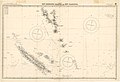 Admiralty Chart No 3033 New Hebrides Islands and New Caledonia, Published 1899.jpg 16,266 × 11,095; 44.4 MB
-
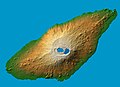 Ambae island 3D pic.jpg 1,234 × 899; 123 KB
-
 Map of Efate Island EN.png 2,903 × 2,226; 362 KB
-
 New Caledonia and Vanuatu bathymetric and topographic map-fr.jpg 2,980 × 2,090; 1.53 MB


