
Category:SVG topographic maps of Vanuatu
Media in category "SVG topographic maps of Vanuatu"
The following 21 files are in this category, out of 21 total.
-
 Banks Islands-en.svg 1,002 × 1,508; 323 KB
-
 Banks Islands-eo.svg 1,002 × 1,508; 323 KB
-
 Banks Islands-fr.svg 1,002 × 1,508; 323 KB
-
 Banks Islands-mk.svg 1,002 × 1,508; 323 KB
-
 Efate relief location map.svg 3,900 × 2,990; 365 KB
-
 Map of Chief Roi Mata's Domain DE.svg 1,400 × 1,600; 216 KB
-
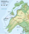 Map of Chief Roi Mata's Domain EN.svg 1,400 × 1,600; 215 KB
-
 Map of Chief Roi Mata's Domain HE.svg 1,400 × 1,600; 243 KB
-
 Map of Chief Roi Mata's Domain mk.svg 1,400 × 1,600; 215 KB
-
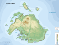
 Map of Efate Island EN.svg 3,900 × 2,990; 563 KB
-
 Map of Efate Island mk.svg 3,900 × 2,990; 556 KB
-
 Map of Efate Island RU.svg 3,900 × 2,990; 577 KB
-
 Map of Efate Island-fr.svg 3,900 × 2,990; 565 KB
-
 Map of Efate Island.svg 3,900 × 2,990; 455 KB
-
 New Caledonia and Vanuatu bathymetric and topographic map-de.svg 2,980 × 2,090; 4.25 MB
-
 New Caledonia and Vanuatu bathymetric and topographic map-fr.svg 2,980 × 2,090; 4.3 MB
-
 New Caledonia and Vanuatu bathymetric and topographic map-mk.svg 2,980 × 2,090; 4.32 MB
-
 Torres Islands-en.svg 938 × 1,235; 169 KB
-
 Torres Islands-eo.svg 938 × 1,235; 170 KB
-
 Torres Islands-fr.svg 938 × 1,235; 169 KB
-
 Torres Islands-mk.svg 938 × 1,235; 170 KB


