
Category:French-language SVG maps
Subcategories
This category has the following 5 subcategories, out of 5 total.
Media in category "French-language SVG maps"
The following 200 files are in this category, out of 1,135 total.
(previous page) (next page)-
 Aavasaksa topographic map-fr.svg 1,368 × 1,688; 271 KB
-
 Abkhazia map-fr.svg 945 × 737; 813 KB
-
 Affaire Louis Mailloux.svg 1,210 × 482; 49 KB
-
 Agde - Plan du fort Brescou 1790.svg 3,007 × 1,944; 105 KB
-

-
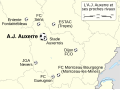 AJ Auxerre et ses clubs voisins map-fr.svg 1,081 × 802; 115 KB
-
 Aldabra islands seychelles-fr.svg 990 × 502; 302 KB
-
 Alençon Alto public transport 2007 map-fr.svg 1,417 × 1,417; 250 KB
-
 Alençon Alto public transport map-fr.svg 1,080 × 1,080; 103 KB
-
 Ambelau Island-fr.svg 771 × 565; 100 KB
-
 Anahim Volcanic Belt-fr.svg 2,334 × 832; 817 KB
-
 Angouleme location map.svg 886 × 744; 5.66 MB
-
 Antemnae.svg 1,935 × 1,128; 72 KB
-
 Apollo 11 photo map-fr.svg 709 × 709; 988 KB
-
 Arc de Berà - Localisation-fr.svg 1,701 × 1,448; 42 KB
-
 Arctic-fr.svg 505 × 633; 1.59 MB
-
 Arles centre-ville map-fr.svg 1,450 × 920; 209 KB
-
 Arles general map-fr.svg 1,150 × 1,300; 36 KB
-
 Arques drainage basin-fr.svg 2,258 × 1,975; 2 MB
-
 Arquipélago das Berlengas-fr.svg 1,643 × 2,743; 209 KB
-
 Ascophyllum nodosum distribution map-fr.svg 1,048 × 931; 1.05 MB
-
 Aube regions map-fr.svg 540 × 394; 78 KB
-
 Azerbaijan topographic map-fr.svg 757 × 502; 3.07 MB
-
 Baie de l'Amirauté.svg 1,349 × 1,410; 490 KB
-
 Baserefl composite comparison fr.svg 1,141 × 543; 1.18 MB
-
 Bavay map-fr.svg 671 × 495; 1.94 MB
-
 Bay-of-Piran maritime-boundary-dispute-fr.svg 789 × 735; 36 KB
-
.svg/120px-Bayeux_-_Plan_des_thermes_gallo-romains_de_la_rue_Laitière_(fouilles_archéologiques_1882_et_1985-1986).svg.png)
-
 Bayeux - Plan à l'époque romaine.svg 3,489 × 2,352; 78 KB
-
 Belle-Île-en-Mer administrative map-fr.svg 1,118 × 878; 1.16 MB
-
 Berlengas archipelago geology-fr.svg 1,183 × 1,593; 77 KB
-
 Berlengas-fr.svg 1,500 × 1,219; 193 KB
-
 Björnlandet national park map-fr.svg 1,431 × 946; 2.73 MB
-
 Bjørnøya map-fr.svg 2,195 × 2,653; 1.79 MB
-
 Boundaries in the Arctic - map-fr.svg 1,335 × 1,335; 969 KB
-
 Bourg de Joué-sur-Erdre.svg 1,755 × 928; 111 KB
-
 Breuschstellung-map-fr.svg 1,047 × 1,167; 497 KB
-
 Bulgaria-geographic map-fr.svg 2,483 × 1,642; 5.23 MB
-
 Cabezo de Alcalá aerial view-fr.svg 1,577 × 1,018; 137 KB
-
 Canton de Lannion position dans les Cotes-d'Armor.svg 711 × 544; 134 KB
-
 Canton-Beaugency-2014.svg 1,452 × 1,117; 755 KB
-
 Canton-Loiret-2014-Gien-details.svg 1,452 × 1,117; 688 KB
-
 Canton-Loiret-2014-Gien.svg 1,452 × 1,117; 830 KB
-
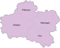
 Cantons-Loiret-2014.svg 1,463 × 1,110; 567 KB
-
 Cap Tourmente map-fr.svg 949 × 684; 328 KB
-
 Caponniere.svg 1,120 × 1,050; 1.48 MB
-
 Capri and Ischia map-fr.svg 802 × 541; 599 KB
-
 Carib Territory-fr.svg 1,406 × 1,116; 27 KB
-
-fr.svg/120px-Carrière_des_Nerviens_(alentours)-fr.svg.png) Carrière des Nerviens (alentours)-fr.svg 1,021 × 1,140; 2.27 MB
Carrière des Nerviens (alentours)-fr.svg 1,021 × 1,140; 2.27 MB
-
 Carte Amitom.svg 2,453 × 1,286; 312 KB
-
 Carte Auschwitz.svg 3,079 × 2,623; 227 KB
-
 Carte baie Howe.svg 1,093 × 921; 94 KB
-
 Carte baie Nootka.svg 566 × 725; 85 KB
-
 Carte baies Desolation et Bute.svg 959 × 909; 64 KB
-
 Carte Bas-Caraquet fr.svg 850 × 666; 367 KB
-
 Carte de la Bèze.svg 1,395 × 2,790; 3.02 MB
-
.svg/120px-Carte_de_La_Demenure_(Joué-sur-Erdre).svg.png) Carte de La Demenure (Joué-sur-Erdre).svg 1,751 × 1,220; 142 KB
Carte de La Demenure (Joué-sur-Erdre).svg 1,751 × 1,220; 142 KB
-
.svg/120px-Carte_de_la_Mulonnière_(Joué-sur-Erdre).svg.png) Carte de la Mulonnière (Joué-sur-Erdre).svg 912 × 507; 51 KB
Carte de la Mulonnière (Joué-sur-Erdre).svg 912 × 507; 51 KB
-
 Carte de la Sarine.svg 512 × 512; 25 KB
-
 Carte de la station Arctowski.svg 744 × 739; 159 KB
-
.svg/120px-Carte_de_localisation_-_Sites_de_Heurtries_II_et_La_Gohaigne_(Quetteville).svg.png) Carte de localisation - Sites de Heurtries II et La Gohaigne (Quetteville).svg 3,367 × 3,620; 144 KB
Carte de localisation - Sites de Heurtries II et La Gohaigne (Quetteville).svg 3,367 × 3,620; 144 KB
-
 Carte des transports en communs entre les bibliothèques de Rennes.svg 1,500 × 1,800; 2.24 MB
-
 Carte des îles Chausey.svg 996 × 486; 338 KB
-
 Carte des Îles Pitcairn.svg 500 × 495; 48 KB
-
 Carte Detail port spatial de Kourou.svg 750 × 1,030; 93 KB
-
 Carte historique du Kamtchatka-fr.svg 3,389 × 3,555; 50 KB
-
 Carte Iles Discovery.svg 1,888 × 924; 166 KB
-
 Carte Miscou.svg 1,150 × 1,230; 341 KB
-
 Carte parc de Sonfjället.svg 1,177 × 899; 2.43 MB
-
 Carte parc national de Tiveden.svg 1,454 × 1,018; 1,016 KB
-
 Carte Pokemouche 2.svg 1,275 × 999; 389 KB
-
 Carte Pokemouche.svg 1,061 × 745; 667 KB
-
 Carte pop urb 2017.svg 1,600 × 1,086; 1.32 MB
-
 Carte populations salish de la cote.svg 1,120 × 588; 157 KB
-
 Carte simplifiée baie Jervis.svg 826 × 882; 128 KB
-
 Carte simplifiée ile Gabriola.svg 1,662 × 921; 64 KB
-
 Carte Store Mosse.svg 1,007 × 1,167; 2.28 MB
-
 Carte topo Caraquet.svg 1,275 × 999; 436 KB
-
 Carte topographique Baie-du-Petit-Pokemouche fr.svg 1,275 × 999; 1.15 MB
-
 Carte topographique Bathurst fr.svg 1,150 × 800; 444 KB
-
 Carte topographique Chiasson-Savoy fr.svg 1,275 × 999; 1.15 MB
-
 Carte topographique de la Bèze.svg 1,395 × 2,790; 5.23 MB
-
 Carte topographique Grande-Anse.svg 1,275 × 999; 122 KB
-
 Carte topographique Haut-Lamèque fr.svg 1,275 × 999; 284 KB
-
 Carte topographique Haut-Shippagan fr.svg 1,275 × 999; 1.15 MB
-
 Carte topographique Lamèque fr.svg 1,275 × 999; 284 KB
-
 Carte topographique Le Goulet fr.svg 1,275 × 999; 1.15 MB
-
 Carte topographique Paquetville.svg 1,275 × 999; 179 KB
-
 Carte topographique Paroisse de Paquetville.svg 1,275 × 999; 182 KB
-
 Carte topographique Pointe-Brûlée fr.svg 1,275 × 999; 1.15 MB
-
 Carte topographique Pointe-Sauvage fr.svg 1,275 × 999; 1.15 MB
-
 Carte topographique Shippagan fr.svg 1,275 × 999; 1.15 MB
-
 Carte Vol Jeju Air 2216.svg 512 × 897; 55 KB
-
 Carte Île-d'Aix.svg 736 × 747; 72 KB
-
 CarteBouctouche.svg 850 × 666; 262 KB
-
 CarteRoute53.svg 500 × 517; 65 KB
-
 CarteRoute72.svg 501 × 514; 101 KB
-
 Castro de la Mesa de Miranda map-fr.svg 961 × 1,290; 17 KB
-
 Caucasus by night.svg 1,155 × 898; 1.04 MB
-
 Caucasus hydro map-fr.svg 1,155 × 898; 5.42 MB
-
 Caucasus mountain range map-fr.svg 1,155 × 898; 5.37 MB
-
 Caucasus topographic map-fr.svg 1,155 × 898; 5.5 MB
-
 Dagestan topographic map-fr.svg 400 × 512; 3.27 MB
-
 North Caucasus topographic map-fr.svg 805 × 394; 3.89 MB
-
 Caucasus-ethnic fr.svg 984 × 1,144; 372 KB
-
 Caucasus-political-fr.svg 972 × 922; 353 KB
-
 Ceinture de feu du Pacifique.svg 943 × 570; 298 KB
-
 Centre Spatial Guyanais orbital launchpads.svg 938 × 788; 36 KB
-
 Centres of origin and spread of agriculture v2.svg 940 × 415; 1.49 MB
-
 Champagne crayeuse map-fr.svg 2,090 × 2,758; 6.98 MB
-
 Changement de la température moyenne.svg 960 × 864; 296 KB
-
 Chateau de Dourdan.svg 1,417 × 1,417; 16 KB
-
 Chatham-Islands map topo-fr.svg 1,669 × 1,425; 746 KB
-
 Chios topographic map-fr.svg 1,580 × 1,150; 1.35 MB
-
 Christmas Island Australia 76-fr.svg 1,241 × 1,123; 245 KB
-
 Châteaubriant 1832.svg 1,280 × 800; 297 KB
-
 Cistercian abbeys of Bourgogne-fr.svg 732 × 891; 221 KB
-
 Climate-tipping-points-fr.svg 2,760 × 1,398; 274 KB
-
 Clos-Masure map-fr.svg 750 × 750; 106 KB
-
 Coalition action against Libya-fr.svg 972 × 1,022; 1.69 MB
-
 Cogne-Acque Fredde - fr.svg 629 × 462; 508 KB
-
 Col d'Arpy map-fr.svg 2,343 × 2,302; 2.66 MB
-
 Col de Joux map-fr.svg 1,939 × 1,945; 1.86 MB
-
 ComputerHotline - Fort-salb-fr.svg 2,980 × 2,105; 123 KB
-
.svg/120px-ComputerHotline_-_Plan-salbert_(by).svg.png) ComputerHotline - Plan-salbert (by).svg 2,980 × 2,105; 280 KB
ComputerHotline - Plan-salbert (by).svg 2,980 × 2,105; 280 KB
-
 ComputerHotline - Storyboard.svg 744 × 1,052; 15 KB
-
 Comtés Nouveau Brunswick Carleton-fr.svg 800 × 800; 59 KB
-
 Comtés Nouveau Brunswick Madawaska-fr.svg 810 × 810; 78 KB
-
 Comtés Nouveau Brunswick Sunbury-fr.svg 805 × 805; 44 KB
-
 Comtés Nouveau Brunswick Victoria-fr.svg 805 × 805; 52 KB
-
 Comtés Nouveau Brunswick York-fr.svg 810 × 810; 87 KB
-
.svg/120px-Constantinople_area_map_(fr).svg.png) Constantinople area map (fr).svg 1,300 × 727; 1.03 MB
Constantinople area map (fr).svg 1,300 × 727; 1.03 MB
-
 Corfu Channel topographic map-fr.svg 595 × 755; 2.22 MB
-
 Corfu topographic map-fr.svg 2,100 × 2,345; 2.46 MB
-
 Corrections eau jura-3.svg 688 × 628; 33 KB
-
 Course Channeltunnel fr.svg 472 × 387; 28 KB
-
 Crau biome area map-fr.svg 995 × 1,020; 698 KB
-
 Crinia bilingua map-fr.svg 1,000 × 600; 277 KB
-
 Croquis d'organisation de la ville de Londres vierge.svg 1,475 × 1,055; 627 KB
-
 Croquis d'organisation de la ville de Londres.svg 1,475 × 1,055; 627 KB
-
 Crozet Islands map-fr.svg 3,849 × 2,505; 1.99 MB
-
 Density evolution Victoria.svg 766 × 569; 244 KB
-
 DEP45 Amilly.svg 842 × 595; 308 KB
-
 Dep45 arron.svg 700 × 555; 121 KB
-
 DEP45 Artenay.svg 842 × 595; 307 KB
-
 DEP45 Beaugency.svg 842 × 595; 308 KB
-
 DEP45 Beaune.svg 842 × 595; 308 KB
-
 DEP45 Bellegarde.svg 842 × 595; 308 KB
-
 DEP45 Briare.svg 842 × 595; 308 KB
-
 DEP45 cantons.svg 758 × 569; 314 KB
-
 DEP45 Chalette.svg 842 × 595; 308 KB
-
 DEP45 Chateauneuf.svg 842 × 595; 307 KB
-
 DEP45 Chateaurenard.svg 842 × 595; 308 KB
-
 DEP45 Chatillon.svg 842 × 595; 308 KB
-
 DEP45 ChatillonsurLoire.svg 842 × 595; 308 KB
-
 DEP45 Checy.svg 842 × 595; 308 KB
-
 DEP45 Cléry.svg 842 × 595; 308 KB
-
 DEP45 com 10000.svg 735 × 590; 346 KB
-
 DEP45 Courtenay.svg 842 × 595; 308 KB
-
 DEP45 Ferrieres.svg 842 × 595; 308 KB
-
 DEP45 Fleury.svg 842 × 595; 308 KB
-
 DEP45 Gien.svg 842 × 595; 308 KB
-
 DEP45 Ingre.svg 842 × 595; 307 KB
-
 DEP45 Jargeau.svg 842 × 595; 307 KB
-
 DEP45 La Ferte.svg 842 × 595; 308 KB
-
 DEP45 Lorris.svg 842 × 595; 308 KB
-
 DEP45 Malesherbes.svg 842 × 595; 308 KB
-
 DEP45 Meung.svg 842 × 595; 308 KB
-
 DEP45 Montargis.svg 842 × 595; 308 KB
-
 DEP45 Neuville.svg 842 × 595; 307 KB
-
 DEP45 Olivet.svg 842 × 595; 307 KB
-
 DEP45 Orleans Bannier.svg 842 × 595; 307 KB
-
 DEP45 Orleans Bourgogne.svg 842 × 595; 307 KB
-
 DEP45 Orleans Carmes.svg 842 × 595; 307 KB
-
 DEP45 Orleans La Source.svg 842 × 595; 308 KB
-
 DEP45 Orleans StMarc.svg 842 × 595; 307 KB
-
 DEP45 Orleans StMarceau.svg 842 × 595; 310 KB
-
 DEP45 Outarville.svg 842 × 595; 308 KB
-
 DEP45 Ouzouer.svg 842 × 595; 307 KB
-
 DEP45 Patay.svg 842 × 595; 298 KB
-
 DEP45 Pithiviers.svg 842 × 595; 308 KB
-
 DEP45 Puiseaux.svg 842 × 595; 308 KB
-
 DEP45 regions nat.svg 699 × 553; 357 KB
-
 DEP45 StJeandeBraye.svg 842 × 595; 308 KB
-
 DEP45 StJeandelaRuelle.svg 842 × 595; 307 KB
-
 DEP45 StJeanleBlanc.svg 842 × 595; 307 KB
-
 DEP45 Sully.svg 842 × 595; 307 KB
-
 Dep45 ZE.svg 700 × 555; 125 KB
-
 Destinations touristiques de Bretagne.svg 1,949 × 1,378; 1.48 MB
-
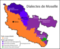 Dialectes de Moselle.svg 745 × 607; 420 KB
-
 Diamond Peak topographic map-fr.svg 3,543 × 2,863; 2.45 MB
-
 Differenciation of Proto-Polynesian map -fr.svg 1,429 × 846; 106 KB
-
 Dinaric Alps map-fr.svg 1,857 × 1,503; 3.63 MB
-
 Dinaric Alps National Parks map-fr.svg 1,857 × 1,503; 3.49 MB
-
 Dinaric Alps subdivisions-fr.svg 1,857 × 1,503; 3.5 MB
-
 Dirk-vents-fr.svg 974 × 812; 1.14 MB
-
 Dist of hu lang europe-fr.svg 688 × 438; 151 KB
-
 Distribution of pottery Neolithic sites in southern Levant-fr.svg 1,984 × 2,952; 87 KB
-
 Districts des îles Truk.svg 912 × 710; 86 KB
-
 Dives - Plan de l'usine et des cités ouvrières.svg 3,238 × 3,008; 128 KB


.svg)


-fr.svg)


.svg)
.svg)


.svg)


.svg)


.svg)


