This is a gallery page containing specially selected image and media files. They have been chosen as highlights of a particular topic, but do not represent the full range of files that are available on Commons. For a wider selection of files connected with Atlas of Țara Bârsei, see Category:Țara Bârsei.
Țara Bârsei este o zonă istorică situată în centrul ► României, având centrul istoric, cultural, economic și social în municipiul Brașov. Denumirea provine de la râul Bârsa (Burzen), care este un afluent al râului Olt. Geografic, Țara Bârsei este o depresiune dispusă în interiorul arcului Carpatic, delimitată de localitățile Apața la nord, Bran la sud, Vlădeni la vest și Prejmer spre est. Totuși, prin tradiție, zona include și comuna Șercaia. Este străbătută de numeroase râuri și pârâuri repezi de munte, fiind delimitată pe o bună porțiune de râul Olt.
Das Burzenland ist eine historische Landschaft im Zentrum Rumäniens, wobei dessen historischer, kultureller, wirtschaftlicher und sozialer Mittelpunkt in Kronstadt liegt. Die Bezeichnung stammt von dem Fluss Burzen, der ein Nebenfluss von Alt ist. Aus geographischer Sicht ist das Burzenland innerhalb des Karpatenbogens ein Tiefland, begrenzt im Norden durch die Ortschaft Geist, im Süden durch die Törzburg, Wladein im Westen und Tartlau im Osten. Traditionell wird auch Schirkanyen hinzugezählt. Die Landschaft wird von zahlreichen Flüssen und Bächen durchflossen und grenzt zu einem bedeutenden Anteil an dem Fluss Alt.
English
Țara Bârsei - Țara Bârsei Țara Bârsei is a historic and ethnographic area in southeastern Transylvania, ► Romania with a mixed population (Romanian, German, Hungarian). Its limits are: Apața village in north, Bran village in south, Perșani and Măgura Codlei Mts. in west and Tărlungeni and Olt rivers in east. Traditionally, the village Șercaia, outside this region, is also part of Țara Bârsei.
This section holds maps of the administrative divisions.
Apața
Bod
Bran
Brașov
Codlea
Cristian
Crizbav
Dumbrăvița
Feldioara
Ghimbav
Hălchiu
Hărman
Holbav
Măieruș
Prejmer
Râșnov
Săcele
Sânpetru
Șercaia
Vulcan
Zărnești
Apața
Bod
Brașov
Feldioara
Prejmer
History maps
This section holds a short summary of the history of the area of present-day Țara Bârsei, illustrated with maps, including historical maps of former countries and empires that included present-day Țara Bârsei.
Brassó county in 1891
Brasso county in 1896
Brassó county in 1910
3rd Military Mapping Survey of Austria-Hungary - Brassó in 1914
Towns and villages in Țara Bârsei
Cristian
Cutuș
Dumbrăvița
Satu Nou
Braşov
Brașov in XVIIth century
Braşov in 1699. Map by Giovanni Morando Visconti.
Brașov in 1897
Brașov in 1905
Brașov in 1922
Old maps
Transylvania in 1451 by Nicolaus Cusanus. Țara Bârsei is VNZEMBORG.
Transylvania in 1493 by Hyeronimus Münzer. Țara Bârsei is WVRTZLANT.
Transylvania at the end of XVth century by Roselli and Germanus.
Transylvania in 1528 by Lazarus Tannstetter. Țara Bârsei is BARTZA PROUINCIA.
Transylvania in 1532, by Johannes Honter.
Țara Bârsei in 1532 by Johannes Honterus. Țara Bârsei is BVRZELAND.
Țara Bârsei in 1552-1556 by Wolfgang Lazius. Țara Bârsei is WURTZLAND/BARZASAG.
Țara Bârsei in 1566 by Sambucus. Țara Bârsei is BURZELAND/BURCIA.
Țara Bârsei in 1598 by A. Ortelius. Țara Bârsei is BURZELAND/BURCIA.
Țara Bârsei in 1630 by Blaew. Țara Bârsei is WURTZLAND/BARZAZAGH.
Țara Bârsei in 1683 by Moses Pitt. Țara Bârsei is WURTZLAND/BARZAZAGH.
Țara Bârsei in 1699 by Giovanni Morando Visconti. Țara Bârsei is PORZELLAND.
Population maps
Țara Bârsei, 2002 demography
Braşov and surrounding area, census 1930
Vlachs (Romanians) in Hungary, census 1890
Territories inhabited by Romanians before 1918
Ethnic map of Austria-Hungary, census 1880. German version
Ethnic map of Austria-Hungary, census 1890. English version
Religions of Austria-Hungary, including Transsylvania
Historical ethnic map of Transylvania
Transylvanian Saxons and Banat Swabians in 1918
Transylvanian Saxons and Banat Swabians in 1945
Satellite-maps
Satellite image of Țara Bârsei
Satellite image of Țara Bârsei
Satellite image of Țara Bârsei
Satellite image of Țara Bârsei
Notes and references
General remarks:
The WIKIMEDIA COMMONS Atlas of the World is an organized and commented collection of geographical, political and historical maps available at Wikimedia Commons. The main page is therefore the portal to maps and cartography on Wikimedia. That page contains links to entries by country, continent and by topic as well as general notes and references.
Every entry has an introduction section in English. If other languages are native and/or official in an entity, introductions in other languages are added in separate sections. The text of the introduction(s) is based on the content of the Wikipedia encyclopedia. For sources of the introduction see therefore the Wikipedia entries linked to. The same goes for the texts in the history sections.
Historical maps are included in the continent, country and dependency entries.
The status of various entities is disputed. See the content for the entities concerned.
The maps of former countries that are more or less continued by a present-day country or had a territory included in only one or two countries are included in the atlas of the present-day country. For example the Ottoman Empire can be found in the Atlas of Turkey.


 Apața
Apața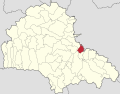 Bod
Bod Bran
Bran Brașov
 Codlea
 Cristian
 Crizbav
 Dumbrăvița
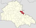 Feldioara
 Ghimbav
 Hălchiu
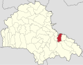 Hărman
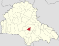 Holbav
 Măieruș
 Prejmer
 Râșnov
 Săcele
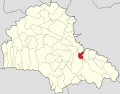 Sânpetru
 Șercaia
 Vulcan
 Zărnești


 Apața
Apața Bod
Bod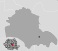 Brașov
 Feldioara
 Prejmer


 Cristian
 Cutuș
Cutuș Dumbrăvița
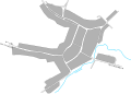 Satu Nou


.png)


.png)


.JPG)
_in_Hungary,_census_1890.jpg)

.jpg)
.JPG)


